
Latest Version
Version
3.0.0
3.0.0
Update
July 09, 2025
July 09, 2025
Developer
JSK Sol
JSK Sol
Categories
Internet
Internet
Platforms
Android
Android
Downloads
0
0
License
Free
Free
Package Name
com.jsk.gpsareameasure
com.jsk.gpsareameasure
Report
Report a Problem
Report a Problem
More About GPS Field Area Measure
Improve your measurements with GPS Field Area Measure. This app helps you accurately measure areas and distances, pick locations, and generate KML reports. Whether you're surveying land, planning projects, or simply exploring new territories, This app has you covered.
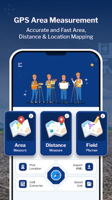
Key Features:
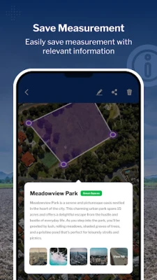
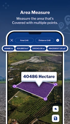
1. Area Measure: Choose between manual or Auto GPS measurement methods to accurately determine the area of any location. Utilize the interactive map screen to define boundaries, select measurable units, and access additional features such as map type changes and information displays. Save your measured areas along with details such as name, description, group classification, and the option to attach photos and notes for future reference.
-Use Land Type annotation for categorize land as agricultural, residential and commercial.
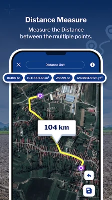
2. Distance Measure: Easily Measure distances using manual or GPS methods. Calculate point-to-point distances on the map screen, view total distances and choose from multiple distance units for convenience. Save your measured distances for quick access and reference along with details such as a name, description, group classification, and the option to attach photos and notes for future reference.
-Use Land Type annotation for categorize land as agricultural, residential and commercial.
-Easily draw plans with support for curved lands or area.
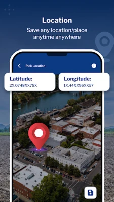
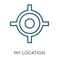
3. Pick Location: Quickly save current or specific locations with customizable details using the Pick Location feature. Store important points of interest for future reference or project planning.
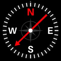
4. Compass: Utilize the built-in compass feature to enhance the accuracy and convenience of your measurements in the field.
5. KML Report: Export KML files to share or analyze your measured data. Generate detailed reports for further analysis or collaboration with team members.
6. Saved List: Access all saved measurements and points of interest in a centralized list format. Organize entries by groups for easy management and retrieval.
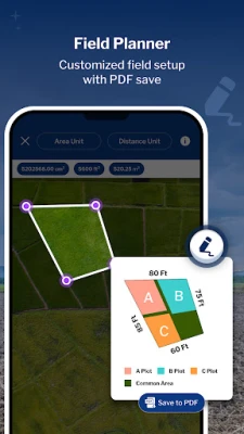
7. Field Planner – Map, Draw, Edit & Share Land Projects
- Perfect for farmers, surveyors, or anyone showcasing land!
- Use map view to draw field boundaries, mark land areas, or plan crop/project layouts.
- Edit or customize your crop area from the map and place it on the canvas as an object.
- Create your plan by adding informative stickers or inserting images from your gallery to make it more detailed
- Export your entire plan as a professional PDF to share or present your land project with ease.
8. Unit Converter – Quick Land & Area Calculations
- Convert between various land units easily—acres, hectares, sq. ft, sq. m, and more. Useful for farmers, builders, and planners who need instant, accurate land conversions on the go.
Permissions
- Location - To get current location and display in map and draw path on map based on location.
- Storage(Android 10) & Read images(Above 10) - To get Images and Save your measured areas along with description.
- Camera - To Capture image for Save with Measurement and description.
1. Area Measure: Choose between manual or Auto GPS measurement methods to accurately determine the area of any location. Utilize the interactive map screen to define boundaries, select measurable units, and access additional features such as map type changes and information displays. Save your measured areas along with details such as name, description, group classification, and the option to attach photos and notes for future reference.
-Use Land Type annotation for categorize land as agricultural, residential and commercial.
2. Distance Measure: Easily Measure distances using manual or GPS methods. Calculate point-to-point distances on the map screen, view total distances and choose from multiple distance units for convenience. Save your measured distances for quick access and reference along with details such as a name, description, group classification, and the option to attach photos and notes for future reference.
-Use Land Type annotation for categorize land as agricultural, residential and commercial.
-Easily draw plans with support for curved lands or area.
3. Pick Location: Quickly save current or specific locations with customizable details using the Pick Location feature. Store important points of interest for future reference or project planning.
4. Compass: Utilize the built-in compass feature to enhance the accuracy and convenience of your measurements in the field.
5. KML Report: Export KML files to share or analyze your measured data. Generate detailed reports for further analysis or collaboration with team members.
6. Saved List: Access all saved measurements and points of interest in a centralized list format. Organize entries by groups for easy management and retrieval.
7. Field Planner – Map, Draw, Edit & Share Land Projects
- Perfect for farmers, surveyors, or anyone showcasing land!
- Use map view to draw field boundaries, mark land areas, or plan crop/project layouts.
- Edit or customize your crop area from the map and place it on the canvas as an object.
- Create your plan by adding informative stickers or inserting images from your gallery to make it more detailed
- Export your entire plan as a professional PDF to share or present your land project with ease.
8. Unit Converter – Quick Land & Area Calculations
- Convert between various land units easily—acres, hectares, sq. ft, sq. m, and more. Useful for farmers, builders, and planners who need instant, accurate land conversions on the go.
Permissions
- Location - To get current location and display in map and draw path on map based on location.
- Storage(Android 10) & Read images(Above 10) - To get Images and Save your measured areas along with description.
- Camera - To Capture image for Save with Measurement and description.
Rate the App
Add Comment & Review
User Reviews
Based on 0 reviews
No reviews added yet.
Comments will not be approved to be posted if they are SPAM, abusive, off-topic, use profanity, contain a personal attack, or promote hate of any kind.


More »

Popular Apps

Voter ConnectVoter Connect

Luxury: Dating App for Elitehoney dating app

Kegel Men: Men's Pelvic HealthMoovBuddy

X Live Wallpaper - HD 3D/4DModel X Apps

Be The One - Columbia ProtocolPROFESSIONAL STAFFING SOLUTIONS, LLC
Compass app - Accurate CompassBattery Stats Saver

Indonesian-English DictionaryAllDict

Paragon Pioneers 2Tobias Arlt
latitude longitude & compassSefanaTech4u Studio

Harley-DavidsonHarley-Davidson Motor Company
More »
Editor's Choice

VeriswapVeriswap

Happy Citizens - Mayor SimLifeSim

College Football PlayoffSIDEARM Sports

ESPNDisney

College Hoops CoachCoach Apps

NCSA Athletic RecruitingNCSA, a subsidiary of IMG Academy Parent, LLC

Contractor ConnectStratus Video, LLC

Watts VisionWatts Water Technologies

AV-ToolboxAkkuVision GmbH

Mail: Email, Cloud, CalendarVKL